School nearby CHAIN
Namibia
School nearby CHAIN
CHAIN
Sindenstreet 17,, Swakopmund, Namibia
contacts phone
:
+264 64 400 744
website:
www.chain.org
Latitude:
-22.6570191
, Longitude:
14.5399161
larger map & directions
read more
nearest School
333 m
Coastal High School
Swakopmund, Skeleton Coast, Namibia
School
read more
532 m
Duckling Daddy Daycare
Roeder, Swakopmund
School
read more
561 m
Tamariskia Primary School
Swakopmund, Skeleton Coast, Namibia
School
read more
753 m
Vrede Rede School
Swakopmund
School
read more
757 m
Festus Gonteb School
8th Avenue West, Swakopmund
School
read more
786 m
Private School Swakopmund
8, Kuhnast, Swakopmund
School
read more
813 m
Privatschule Swakopmund
Vineta
School
read more
859 m
Swakop Primary School
Riesle, Swakopmund
School
read more
972 m
Mondesa Youth Opportunities Trust
Mondesa
School
read more
1.066 km
Atlantic High School
Mossie, Swakopmund
School
read more
1.261 km
Windhoek
Swakopmund
School
read more
1.419 km
Westside High School
Swakopmund, Skeleton Coast, Namibia
School
read more
1.617 km
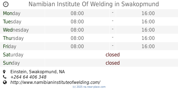
Namibian Institute Of Welding
Einstein, Swakopmund
School
read more
1.636 km
Atheneum Preschool
Foxglove street, Swakopmund
School
read more
1.759 km
Swakopmund School Of Excellence
Swakopmund
School
read more
1.995 km
Swakopmund Secondary School
Swakopmund, Skeleton Coast, Namibia
School
read more
2.337 km
Namib High School
Swakopmund
School
read more
2.365 km
Georg Ludwig Kindergarten
Swakopmund
School
read more
2.501 km
Swakopmund Christian Academy
Swakopmund
School
read more
2.575 km
Pro-Ed Academy
Riverside Avenue, Swakopmund
School
read more
2.755 km
Privates Deutsches Schülerheim Swakopmund
Luderitz Street, Swakopmund
School
read more
3 km
Namib Primary School
Swakopmund
School
read more
3.429 km
Pro Ed Akademie
Swakopmund
School
read more
6.319 km
Swakopmund Secondary School
Swakopmund
School
read more
📑
all categories
Accounting
Administrative area level 1
Airport
Art gallery
Atm
Bakery
Bank
Bar
Beauty salon
Bicycle store
Book store
Bowling alley
Bus station
Cafe
Campground
Car dealer
Car rental
Car repair
Car wash
Casino
Cemetery
Church
City hall
Clothing store
Convenience store
Courthouse
Dentist
Department store
Doctor
Electrician
Electronics store
Embassy
Establishment
Finance
Fire station
Florist
Food
Funeral home
Furniture store
Gas station
General contractor
Grocery or supermarket
Gym
Hair care
Hardware store
Health
Home goods store
Hospital
Insurance agency
Jewelry store
Laundry
Lawyer
Library
Liquor store
Local government office
Locality
Lodging
Meal delivery
Meal takeaway
Mosque
Movie theater
Moving company
Museum
Natural feature
Neighborhood
Night club
Park
Parking
Pet store
Pharmacy
Physiotherapist
Place of worship
Plumber
Point of interest
Police
Political
Post office
Premise
Real estate agency
Restaurant
Route
School
Shoe store
Shopping mall
Spa
Stadium
Storage
Store
Supermarket
Taxi stand
Train station
Travel agency
University
Veterinary care
Zoo
sublocality level 1
↑